


Profitis Ilias, Ambelos Mt. Nov. 2011.
Photo: Torben & Jan. Text: Torben.
One morning (about 7 o'clock) on my way back from my morning swim I had this nice view to the mountains.
I decided to have a tour up there as soon as possible.
![[View to Ambelos Mt.]](/images/stories/Winter/Profitis-Ilias-Nov11W/_DSC1453a.jpg)
The next day Jan and I took a tour up there, and it was as always a great tour.
![[Ilias Map]](/images/stories/Winter/Profitis-Ilias-Nov11W/Ilias-Map.gif)
Location of Profitis Ilias.
![[View to Kerkis]](/images/stories/Winter/Profitis-Ilias-Nov11W/_DSC1476_Panorama1.jpg)
View from Prof. Ilias to Kerkis Mt.


The reflectors:
![[View to Kerkis]](/images/stories/Winter/Profitis-Ilias-Nov11W/19_P-Elias_Panorama2.jpg)
It has not been possible to get an official explanation on the use of the 2 big reflectors on the top.
Therefore I had to figure out what the use might have been.
After working with electronic, radar and radio for more than 40 years it was obvious to me
that it was a set of passive reflectors for radio communication, but from where to where?
| A reflector acts as a mirror as shown here and to find the direction and possible 'endpoints' it is necessary to make a few measurements and calculations. | 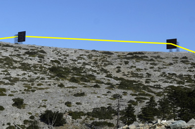 |
|
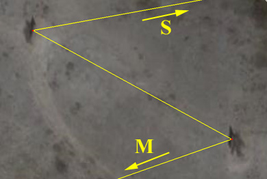
To make a long story short I have made these illustrations using Google Earth. First a sight-line between the centres of the reflectors. Then constructing the 'reflection' of this line. Final step is to extend the reflection-lines and see where they ends. |
 |
|
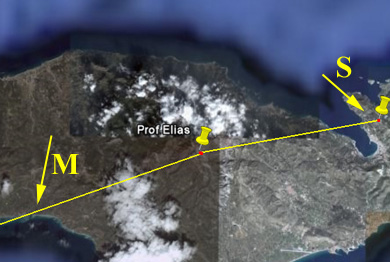
The lines passes Marathokambos (M) and a point close to Samos town (S). To see if this make any sense we have to enlarge the map, and the following pictures will tell us... |
 |
|
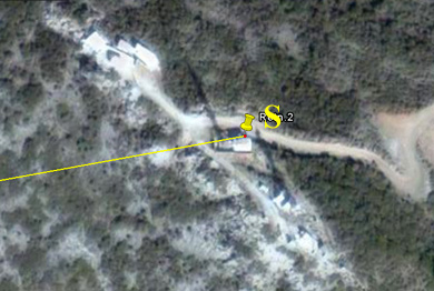
The line marked "S" passes the radio station close to Profitis Ilias above Samos town. If this station have used the reflectors or if an earlier installation in that area used them is not to say at this moment. I will try to find the answer on my next tour to Samos. |
 |
| The line marked "M" passes right through Marathokambos. | 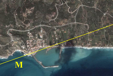 |
My conclusion and best guess is that the purpose of the reflectors was to establish radio communication or radio transmission (one- or two-way) between Samos and Marathokambos area.